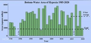
NOAA-supported scientists have determined this year’s Gulf of Mexico “dead zone” — an area of low to no oxygen that can kill fish and marine life — is approximately 2,116 square miles, or equivalent to 1.4 million acres of habitat potentially unavailable to fish and bottom species. The measured size of the dead zone is the third smallest in the 34-year record of surveys. However, the average hypoxic zone over the past five years is 5,408-square miles, which is 2.8 times larger than the 2,035 target set by the Hypoxia Task Force.
The annual dead zone survey was led by scientists at Louisiana State University and the Louisiana Universities Marine Consortium during a research cruise from July 25 to August 1 aboard the R/V Pelican.
Effects of Hurricane Hanna
This year, Hurricane Hanna passed through the central and western Gulf days prior to the research cruise and mixed the water column, disrupting the hypoxic zone which forms in the coastal ocean west of the Mississippi River delta. While the size of the hypoxic zone fluctuates naturally throughout the summer, it usually forms again within days or weeks after the passage of storms. Due to the close proximity of the storm to the survey cruise, the hypoxia area was only able to partially reform before the end of the monitoring cruise, resulting in a patchy distribution across the Gulf.
Nancy Rabalais, Ph.D., professor at Louisiana State University and LUMCON who is the principal investigator said, “The consistent winds from the south generated downwelling favorable conditions, and the remaining low oxygen was further offshore, in deeper water than normally. Vertically uniform temperature, salinity, and dissolved oxygen data across the broad area mapped is not the norm for a July shelf-wide hypoxia cruise.” Cassandra Glaspie, Ph.D., of LSU was the chief scientist on board the Pelican, due to an injury to Dr. Rabalais, who attended stations virtually and guided the small science crew, which was limited due to Covid-19 restrictions.
In June, NOAA forecasted a larger-than-average hypoxic zone of 6,700 square miles, smaller than the record size of 8,776 square miles set in 2017. The forecast relies primarily on the Mississippi River discharge and nutrient runoff data from the U.S. Geological Survey. With elevated discharge and nutrient loading this spring, the models predicted a larger than average hypoxic zone to form during the time of the cruise. The forecast models assume typical weather conditions and only have a limited capacity to factor in storms such as Hurricane Hanna and other wind events, which can disrupt the hypoxia zone around the time of the cruise.
Collaboration among federal partners, states, farmers, and others
While the annual hypoxic zone measurement provides an important datapoint, equally important is the robust and effective work being done to reduce excess nutrients in water across the Mississippi and Atchafalaya River Basin,” said EPA Assistant Administrator for Water David Ross. “Fostered by the Hypoxia Task Force and driven by leadership at the state level, the sustained use of best-practices and innovative new approaches is and will continue to improve water quality while supporting agriculture and communities in America’s heartland.”
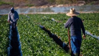
The HTF is accelerating progress in reducing excess nutrients in the Mississippi/Atchafalaya River Basin by promoting collaboration among federal partners, states, farmers and other stakeholders. Federal agencies are supporting efforts to reduce excess nutrients, including by making $17.5 million available in 2020 to support conservation investments by agriculture producers through the U.S. Department of Agriculture’s Mississippi River Basin Healthy Watersheds Initiative. USDA is also providing more than $38 million to support producers in 300 small watersheds across the nation, including many watersheds in the Mississippi River Basin.
Additionally, new initiatives such as NOAA’s Runoff Risk Forecast are reaching new states and are designed to help farmers apply fertilizer at optimum times to ensure it stays on fields and reduce nutrient runoff to the Gulf is limited. The HTF also empowers state programs by sharing successful strategies and providing funding to states to support program development and implementation efforts that are tailored to finding local solutions. The success of these efforts has been demonstrated by USDA’s Conservation Effects Assessment Project and by annual reports, such as Iowa’s Nutrient Reduction Strategy Annual Report, that describe state progress.
Excess nutrients stimulate algae growth
Each year, excess nutrients from cities, farms, and other sources in upland watersheds drain into the Gulf and stimulate algal growth during the spring and summer. The algae eventually die, sink, and decompose. Throughout this process, oxygen-consuming bacteria decay the algae. The resulting low oxygen levels near the bottom are insufficient to support most marine life, rendering the habitat unusable and forcing species to move to other areas to survive. Exposure to hypoxic waters has been found to alter fish diets, growth rates, reproduction, habitat use, and for harvested species like shrimp availability to the fishery.
The annual hypoxic zone size determination is a key metric used by the Mississippi River/Gulf of Mexico Watershed Nutrient Task Force to measure progress toward achieving the five-year average target of 1,900-square-miles or smaller by 2035. As the survey cruise is only a snapshot of the hypoxic zone, calculating a five-year average captures the true dynamic nature of the zone more than a single annual measurement.