Kansas State University has a new tool to help farmers assess when temperature inversions occur in their region — information that can be very useful in assessing the risk for dicamba drift.
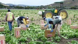
The EPA listed temperature inversion as a factor that contributes to the unintentional spread of dicamba into areas that weren’t targeted.
Temperature inversion is a weather phenomenon in which the air at the earth’s surface is cooler than the air above it – a situation different than the norm, said Christopher “Chip” Redmond, manager of Kansas Mesonet. During times of temperature inversion, which usually happen at night or on cloudy days, the risk that dicamba can drift onto nearby fields and damage other crops is heightened.
The new information is available on the Kansas Mesonet website. Kansas Mesonet is a network of 58 weather stations situated around the state, which measure such weather parameters as temperature, wind speed, precipitation and humidity. The data is recorded at the Kansas Weather Data Library, based at K-State.
“That (temperature inversion) typically develops due to the lack of soil radiation. As soon as you lose that sunshine in the afternoon or if it gets cloudy, the surface starts to cool off,” Redmond said.
In response to the dicamba problem, Redmond and K-State agronomy professors Dallas Peterson and Curtis Thompson developed the tool which Redmond said should be used to determine trends in particular areas rather than as a decision-making tool regarding exactly when or when not to spray.
“Unfortunately, many folks aren’t that familiar with temperature inversions and intuitively think that when the wind dies down in the evening or early morning, that is the best time to spray,” Redmond said. “However, if they spray during a temperature inversion, there actually may be much greater risk of off-target herbicide injury than when there is a 3 to 10 mile-per-hour wind blowing away from the direction of susceptible crops and species. It’s (inversion data) not something to look at and say ‘there’s an inversion in place so I shouldn’t spray right now or that there’s not an inversion in place so I can spray.”
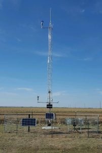
The weather stations measure the temperature at 6 feet and 30 feet from the ground, which helps develop a vertical view of the lower atmosphere, where these surface inversions occur. The Mesonet aims to also develop a climatology of frequency, depth, occurrence, and what kind of weather scenarios come together to develop inversions.
“What we’re finding is that temperature inversions often develop one to two hours before sunset. They are often strongest just after sunset, persisting throughout the night varying in strength. Typically, surface inversions disperse an hour or two after sunrise, when the sun begins to warm the surface,” Redmond added.
He encourages producers to start monitoring inversions in their area to obtain a feel for dominant wind directions under inversions. If the air were completely still, there wouldn’t be a problem, but winds average 2 to 4 miles per hour in an inversion – those winds can transport the herbicide spray molecules a fairly long distance.
“This tool can help with determining dominant wind flows in your area under an inversion, which may provide some indication where drifting could occur,” Redmond said.